Services: Consulting & Teaching
Practice: Planning and Urban Design
In 1972 in Milwaukee Larry began his twin careers as a professor and practitioner. Over the next 50+ years he continued to intertwine his practical and theoretical expertise. In 2017 he was named the American Planning Association’s Planning Pioneer of the Year. His professional achievements have been recognized by Progressive Architecture, the American Institute of Architects, the Congress for the New Urbanism, the American Planning Association as well as local, state and regional organizations. Dr. Witzling led the Planning & Design Institute, Inc. (PDI), partnered with Jeffrey Ollswang in Design Competition Services where they conducted more than 20 national and international design competitions, and provided planning leadership at GRAEF engineering from 2008 until 2025. He is a Professor Emeritus at the University of Wisconsin - Milwaukee where he continues to teach new generations of planners and designers. His areas of practice (illustrated in the pages of this section) focus on:
Urban design for community development
Urban design determines the physical form of the city by creating the streets, parcels, blocks and buildings that can be developed. Urban design establishes the opportunities and constraints whereby we make the city which, in turn, influences social and economic activates, circulation, the natural environment, and the long-term sustainability of the community. Far more than a supplement to a city’s visual appeal, urban design is the foundation of how a city will evolve over time. The following projects illustrate the use and impact of effective urban design.
The Park East freeway redevelopment plan
The removal and redevelopment of Milwaukee’s Park East freeway was one of the first major urban design projects to reunite land use development and transportation. This required unique talents and insights that including:
Drafting a Context based street and block plan - Detailed analysis of the surrounding context in terms of overlapping neighborhoods, social and economic diversity, and opportunity for growth
Writing Clear policies for new development - Creation of regulations and policies, in a context dependent form-based code, that structure broad opportunities for development while setting clear constraints to keep the buildings and streets integrated
Preparing Strong communication to the public - Illustrations, most importantly in the form of a three-dimensional physical model, that communicated tow the form and character of the city could be improved in a way that allowed substantial growth but did not reflect or depend on the urban renewal practices using mono-culture development and architecture
Facilitating Incremental growth without radical impacts - Facilitating a phased management. Process that allowed for growth of private sector uses incrementally such that major impacts on businesses and economic development could be grow organizable rather than in a forced manner.
Kenosha downtown design and development
Harlan Bartholomew, an engineer who was part of the early professional planning movement, developed Kenosha’s general plan which included many of the principals and concepts of the City Beautiful movement adapted to the local structure of streets and block. The plan, which was adopted during the heyday of America’s industrial expansion, did not however unify the north and south sides of the city along the Lake Michigan shoreline. IN fact, much of the plan reinforced this dichotomy. The Kenosha Downtown Design and Development Plan, however, devised a system of streets and blocks that fully integrated the disparate pieces of the city. This was the first plan which emulated the words of Daniel Burnham (also the designers of Kensha’s Library and adjacent square) to create a “noble diagram” that could become the central concept for future growth for the next 30+ years.
Racine, Water Street redevelopment, 2023
Reconnection planning Highway 175, Milwaukee 2025
Expert testimony for planning practices
Town of Windsor and Village of DeForest annexation
Koshkonong Solar Array
Village of Caledonia, incorporation
Elkhorn and Town of Sugar Creek annexation
Design competition management
World Trade Center Memorial, New York City
Leesburg town center and city hall
Pittsburgh Convention Center
Astronauts Memorial, Cape Canaveral
Property development for mixed use places
Luxembourg American Cultural Center
Monroe Street, Madison Wisconsin
Milwaukee River - North End, Flat Iron, Riverside, Beerline
Development capacity analysis
Drexel Town Square, Oak Creek Wisconsin
Waukesha city center
Sun Prairie, West Prairie Village
Wauwatosa downtown and Regional Medical Center
Teaching Architecture and Urban Planning
Since 2020 Larry has been teaching as an adjunct at the UWM School of Architecture and Urban Planning. Currently he teaches an introductory course enrolled primarily by new freshmen and sophomores. His lectures in this class cover a broad specctrum of topics. The following illustrations inlcude images he uses during the 15 week series of lectures:
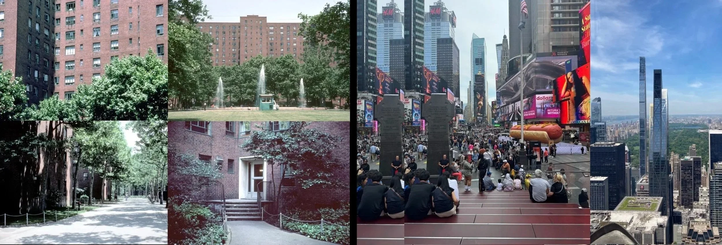
At the start of a class in architecture or urban planning I begin with images of where I grew up (Stuyvesant Town in Manhattan) and the larger urban context containing forms and experiences which influenced my understanding of the urban environment (Times Square and the Manhattan Skyline).
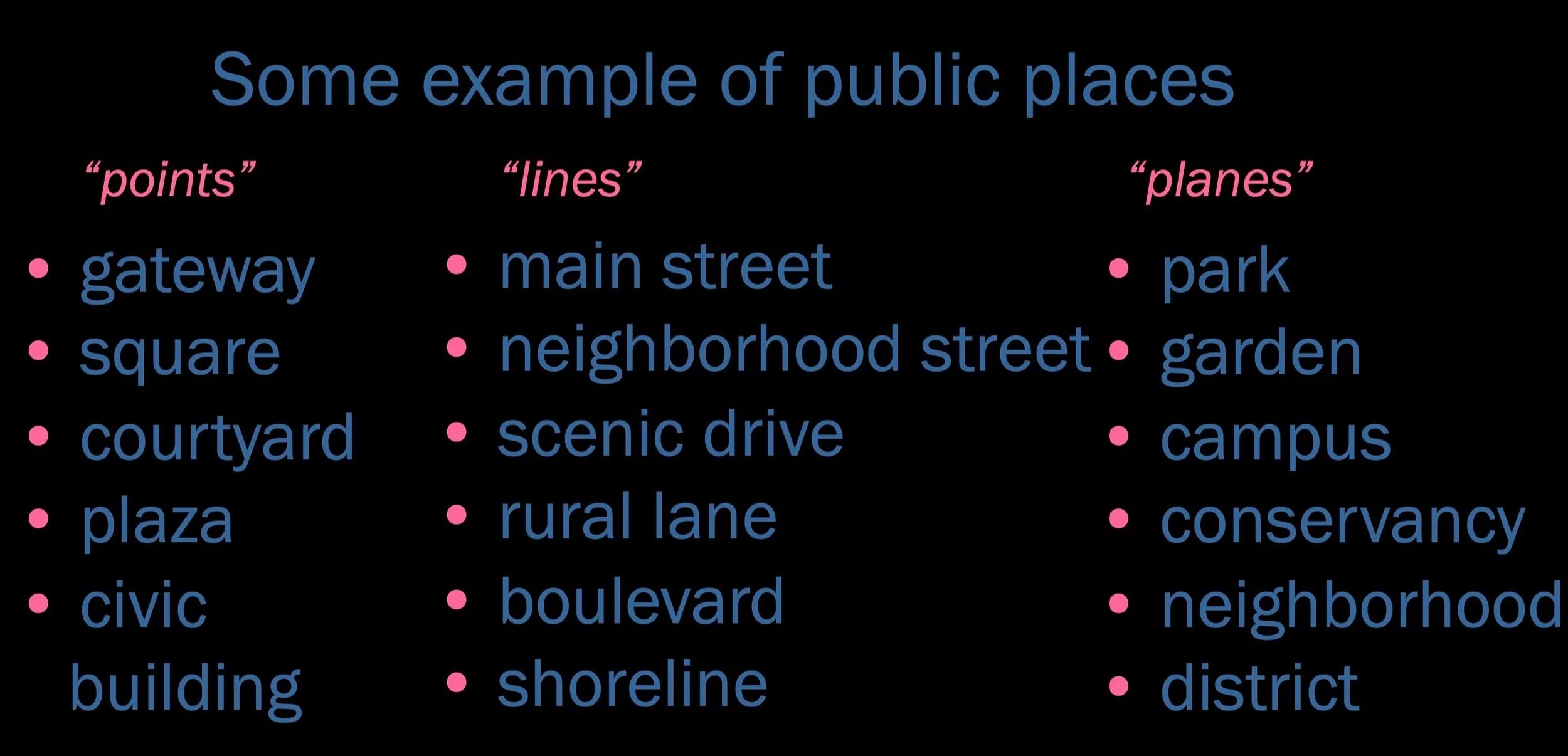
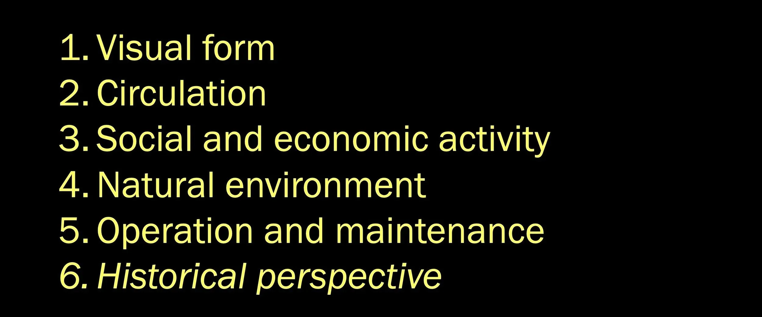
When students look at large urban maps and figure-ground illustrations, I suggest that they think of them as simple geometries of points, lines, and planes which, dependent upon the scale of the map, represent different types of urban places.
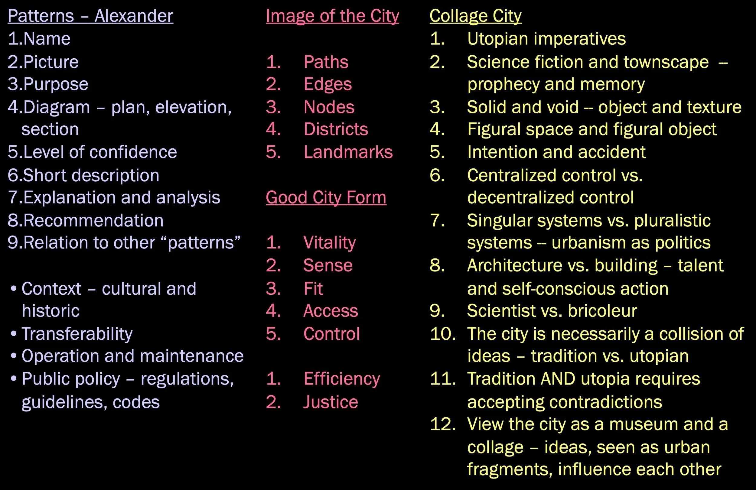
During the lecture series on urban design I discuss several theories which have pragmatic value for planning practice. The image to the left lists critical issues in the theories which I emphasize.
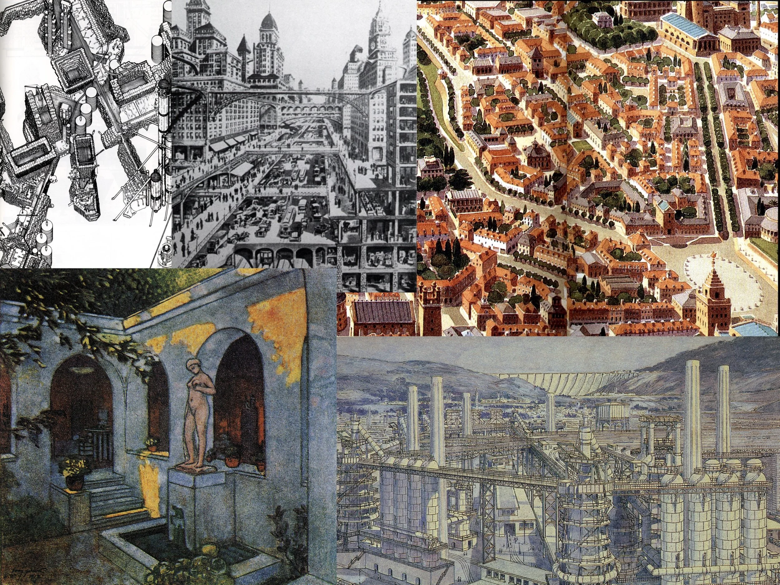
A key point in the discussion of the design of cities rests on the idea of “Collage” as discussed by Collin Rowe. This concept overlaps the idea of the city as a “museum” with different areas representing different historical and cultural components. I use images like the one on the left where I ask students “what would it be like to live in a city that contained places like those in this illustration”
Cityland Essays
Copyright Larry Witzling 2025
urban design, city planning
Although it represents a gross oversimplificatio, I suggest that students address all 6 of the iissues listed on the left in any planning and design project they unertake as students.
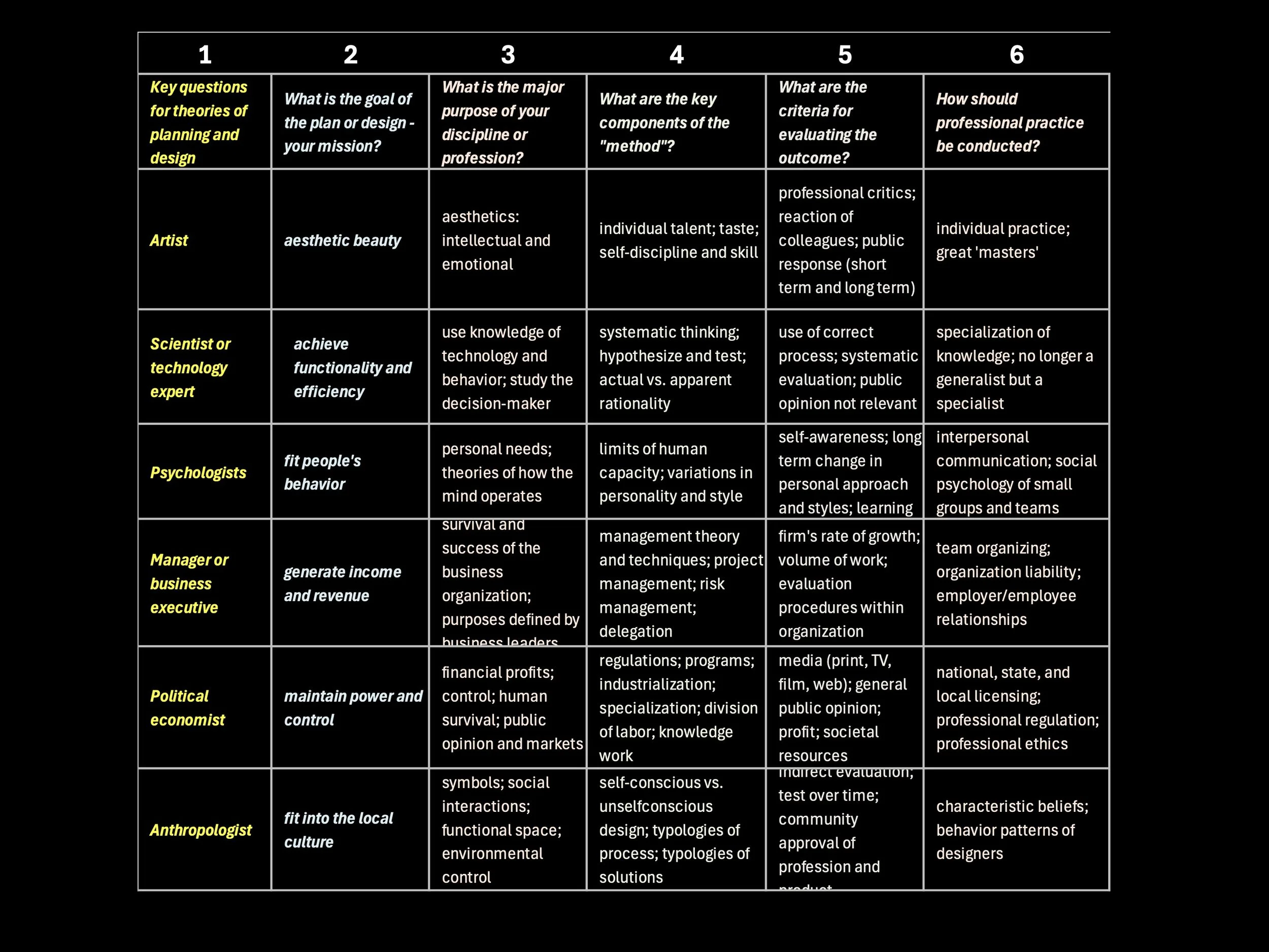
As a graduate student, learning the different models of planning practice advocated in different fields, I created this matrix with the intent of understanding that any attempt at planning and urban design practice probably needed to allow for a broad range of theories, often with inherent contradictions, to govern professional practice. The educational goal is to help students become more open-minded.
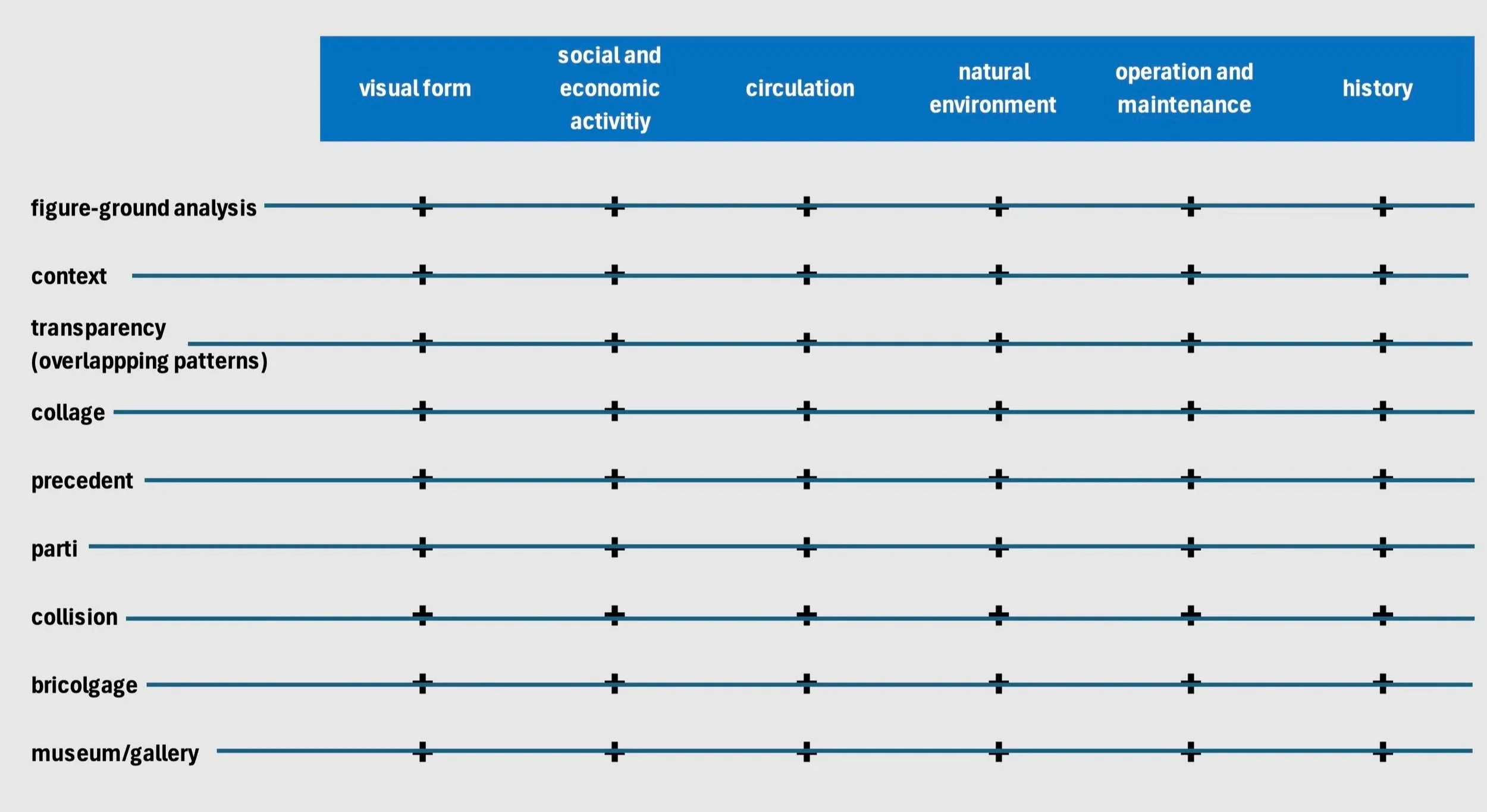
The top row includes the topics which every student should learn and include in planniing and urban design studies (there are more, but these six are essential). The list on the left side represents skill sets (or the ideas underlying skill sets) that all planning and urban design practitioners should master. The lines and marks imply that all the topics and all the skill sets are intertwined in professional practice (perhaps not in academia).